Stage 13
Kirkbride (EGSA) to Caernarfon (EGCK)
The Cumbrian Coast, Morecambe Bay, and North Wales
Distance
138.0 NM
Est. Time (150kts)
00h 55m
Target Alt
2,500 ft
Touch & Gos
2 Airfields
Departure: EGSA (Kirkbride)
- Elevation: 49 ft
- Runway: 09/27 (1,308m Asphalt/Concrete)
- Fuel: Avgas 100LL (PPR)
- Comms: Radio 122.480 | DCS VOR 113.30
Arrival: EGCK (Caernarfon)
- Elevation: 31 ft
- Runway: 01/19 (820m Asphalt) | 07/25 (560m Asphalt)
- Fuel: Avgas 100LL available
- Comms: Air/Ground 119.330 | MCT VOR 116.40
Visual Route Map & Navaids (High Detail)
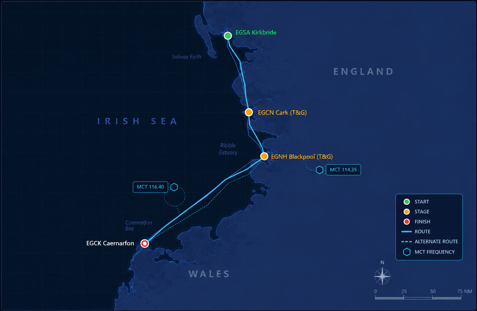
Navigation & Waypoint Breakdown
| Ident | Type | Track (°M) | Nav Aid / Radial | Dist | ETE | Landmarks & Notes |
|---|---|---|---|---|---|---|
| EGSA | Departure | -- | DCS 113.30 | 0.0 NM | 00:00 | Depart Kirkbride, tracking South down the Cumbrian coastline. |
| EGCN | Touch & Go | 165° | Visual (Morecambe Bay) | 52.0 NM | 00:21 | Skirt past Whitehaven and Barrow-in-Furness. T&G at Cark grass airfield. |
| EGNH | Touch & Go | 155° | BLCK 114.35 | 34.0 NM | 00:34 | Cross Morecambe Bay. Fast T&G at Blackpool Airport. |
| EGCK | Arrival | 235° | MCT 116.40 R-270 | 52.0 NM | 00:55 | Cross the Irish Sea / North Wales coast to land at Caernarfon. |
Local Notes & Flying Tips
- Morecambe Bay Crossing: Heading south from Cark to Blackpool, you cross wide expanses of tidal sands. Keep a good visual check on the coastline and utilize the Blackpool VOR to keep your track tight.
- Blackpool Tower: During your approach for the T&G at EGNH, you'll get a classic view of the Blackpool seafront and tower just north of the field.
- Caernarfon Approach (EGCK): Situated on the Menai Strait with the peaks of Snowdonia looming right behind you, the scenery here is breathtaking. Watch out for mountain rotor and wind shear if the breeze is blowing off the high ground.
Digital Asset Pack
EFB / SkyDemon Route String
EGSA EGCN EGNH EGCKGarmin TDS GTNXi Format (.gfp)
FPN/RI:EGSA:EGCN:EGNH:EGCKSave as Stage13.gfp or paste directly into the TDS flight plan catalog.
MSFS .pln File
<?xml version="1.0" encoding="UTF-8"?>
<SimBase.Document>
    <FlightPlan.FlightPlan>
        <Title>EGSA to EGCK Stage 13 UK Coastal Circumnavigation</Title>
        <FPType>VFR</FPType>
        <RouteType>Direct</RouteType>
        <CruisingAlt>2500</CruisingAlt>
        <DepartureID>EGSA</DepartureID>
        <DepartureLLA>N54° 52' 50.00",W3° 12' 21.00",+000049.00</DepartureLLA>
        <DestinationID>EGCK</DestinationID>
        <DestinationLLA>N53° 6' 28.00",W4° 20' 28.00",+000031.00</DestinationLLA>
        <ATCWaypoint id="EGSA">
            <ATCWaypointType>Airport</ATCWaypointType>
            <WorldPosition>N54° 52' 50.00",W3° 12' 21.00",+000049.00</WorldPosition>
            <ICAO><ICAORegion>EG</ICAORegion><ICAOIdent>EGSA</ICAOIdent></ICAO>
        </ATCWaypoint>
        <ATCWaypoint id="EGCN">
            <ATCWaypointType>Airport</ATCWaypointType>
            <WorldPosition>N54° 8' 56.00",W3° 0' 32.00",+000025.00</WorldPosition>
            <ICAO><ICAORegion>EG</ICAORegion><ICAOIdent>EGCN</ICAOIdent></ICAO>
        </ATCWaypoint>
        <ATCWaypoint id="EGNH">
            <ATCWaypointType>Airport</ATCWaypointType>
            <WorldPosition>N53° 46' 25.00",W3° 1' 44.00",+000034.00</WorldPosition>
            <ICAO><ICAORegion>EG</ICAORegion><ICAOIdent>EGNH</ICAOIdent></ICAO>
        </ATCWaypoint>
        <ATCWaypoint id="EGCK">
            <ATCWaypointType>Airport</ATCWaypointType>
            <WorldPosition>N53° 6' 28.00",W4° 20' 28.00",+000031.00</WorldPosition>
            <ICAO><ICAORegion>EG</ICAORegion><ICAOIdent>EGCK</ICAOIdent></ICAO>
        </ATCWaypoint>
    </FlightPlan.FlightPlan>
</SimBase.Document>