
Stage 03
Charterhall Airfield (EGFQ) to Fife Airport (EGPJ)
Scottish Borders, Firth of Forth & Kingdom of Fife
Distance
52.4 NM
52.4 NM
Est. Time (ETE)
00h 38m
00h 38m
Target Alt
2,000–2,500 ft
2,000–2,500 ft
Touch & Gos
1 Airfield
1 Airfield
Route Map & Radio Navaids Visual

TLA VOR/DME (113.80): Outbound reference across Lammermuir Hills (R-055)
PTH VOR/DME (112.40): Inbound tracking across Firth of Forth to Fife (R-115)
EDINBURGH RADAR (121.205): Lower airspace radar service / CTR avoidance
Navigation & Waypoint Breakdown
| Ident | Type | Track (°M) | Nav Aid / Radial | Alt | Leg | Total | ETE | Landmarks & Notes |
|---|---|---|---|---|---|---|---|---|
| EGFQ | Departure | — | TLA 113.80 R-105 | 380 ft | 0.0 NM | 0.0 NM | 00:00 | Depart Charterhall north over the Lammermuir Hills. |
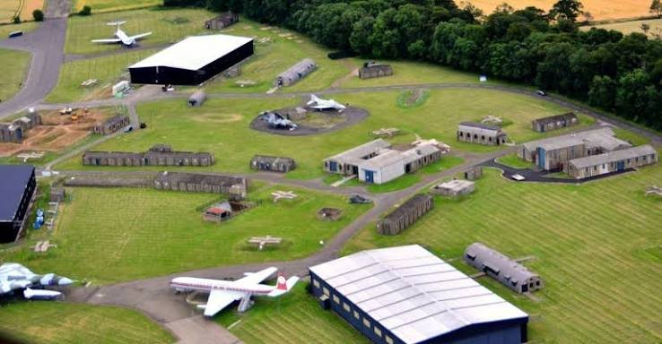
| EGHA | Touch & Go | 348° | TLA 113.80 R-055 | Circuit | 21.2 NM | 21.2 NM | 00:15 | East Fortune (Museum of Flight); touch & go on historical runway. |
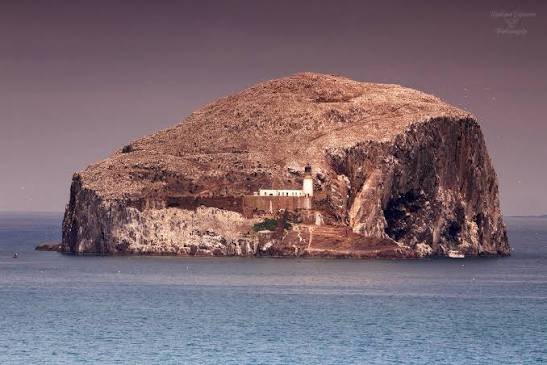
| BASSROCK | Coastal VRP | 020° | TLA 113.80 R-048 | 2,500 ft | 5.0 NM | 26.2 NM | 00:19 | Steep volcanic crag island in the Forth; turn west for water transit. |
| LETHANGIE | Inland VRP | 292° | PTH 112.40 R-115 | 2,000 ft | 24.1 NM | 50.3 NM | 00:36 | Cross Firth of Forth north of Edinburgh CTR; identify Loch Leven. |
| EGPJ | Arrival | 245° | PTH 112.40 R-130 | 400 ft | 2.1 NM | 52.4 NM | 00:38 | Turn south into Fife Airport (Glenrothes) for full stop landing. |
Stage Highlights & Scenic Landmarks

Radio Navigation Frequencies
- Perth VOR/DME (PTH): 112.40 MHz
- Talla VOR/DME (TLA): 113.80 MHz
- Edinburgh Radar: 121.205 MHz
- Fife Radio / SafetyCom: 122.805 MHz
Local Cautions & Airspace
- Edinburgh Controlled Airspace: Class D CTR/CTA bounds the water transit to the south. Maintain 2,000–2,500 ft and remain well east of the Forth Bridges unless cleared.
- Bird Strike Hazard: High risk of seabird concentration (gannets, gulls) around Bass Rock and Firth of Forth coastal margins.
- Fife Circuit: Standard left-hand circuits; watch for light training aircraft operating on Runway 06/24.
Download MSFS Flight Plan (.PLN)
Copy the XML snippet below and save it as UK_Coastal_Stage_03.pln to load directly into Microsoft Flight Simulator:
<?xml version="1.0" encoding="UTF-8"?>
<SimBase.Document>
    <FlightPlan.FlightPlan>
        <Title>EGFQ to EGPJ Stage 3 UK Coastal Circumnavigation</Title>
        <FPType>VFR</FPType>
        <RouteType>Direct</RouteType>
        <CruisingAlt>2500</CruisingAlt>
        <DepartureID>EGFQ</DepartureID>
        <DepartureLLA>N55° 42' 18.00",W2° 21' 40.00",+000380.00</DepartureLLA>
        <DestinationID>EGPJ</DestinationID>
        <DestinationLLA>N56° 11' 00.00",W3° 13' 10.00",+000400.00</DestinationLLA>
        <ATCWaypoint id="EGFQ">
            <ATCWaypointType>Airport</ATCWaypointType>
            <WorldPosition>N55° 42' 18.00",W2° 21' 40.00",+000380.00</WorldPosition>
            <ICAO><ICAORegion>EG</ICAORegion><ICAOIdent>EGFQ</ICAOIdent></ICAO>
        </ATCWaypoint>
        <ATCWaypoint id="EGHA">
            <ATCWaypointType>Airport</ATCWaypointType>
            <WorldPosition>N55° 59' 32.00",W2° 43' 00.00",+000160.00</WorldPosition>
            <ICAO><ICAORegion>EG</ICAORegion><ICAOIdent>EGHA</ICAOIdent></ICAO>
        </ATCWaypoint>
        <ATCWaypoint id="BASSROCK">
            <ATCWaypointType>User</ATCWaypointType>
            <WorldPosition>N56° 04' 36.00",W2° 38' 24.00",+002500.00</WorldPosition>
        </ATCWaypoint>
        <ATCWaypoint id="LETHANGIE">
            <ATCWaypointType>User</ATCWaypointType>
            <WorldPosition>N56° 13' 12.00",W3° 24' 18.00",+002000.00</WorldPosition>
        </ATCWaypoint>
        <ATCWaypoint id="EGPJ">
            <ATCWaypointType>Airport</ATCWaypointType>
            <WorldPosition>N56° 11' 00.00",W3° 13' 10.00",+000400.00</WorldPosition>
            <ICAO><ICAORegion>EG</ICAORegion><ICAOIdent>EGPJ</ICAOIdent></ICAO>
        </ATCWaypoint>
    </FlightPlan.FlightPlan>
</SimBase.Document>- 1. Departure from Charterhall (EGFQ)
Charterhall has no active controller. On SayIntentions, broadcast your intentions to the “Traffic” pool on the UK Safety Frequency to simulate local awareness.
Taxi Broadcast:You: “Charterhall Traffic, Golf-ABCD, Cessna 172 taxiing to holding point Runway 25 for VFR departure to the north.”
Departure Broadcast:You: “Charterhall Traffic, Golf-ABCD, lining up and departing Runway 25, climbing to 2,500 feet, routing north towards East Fortune.”
2. En-Route & Requesting Basic Service
Once clear of the Charterhall area and climbing, switch to Scottish Information to get your regional altimeter setting (QNH) and track your flight.
Initial Call:You: “Scottish Information, Golf-ABCD, request Basic Service.”
ATC: “Golf-ABCD, Scottish Information, pass your message.”
Full Position Report (CARER format):You: “Golf-ABCD, Cessna 172, from Charterhall to Fife via East Fortune. 5 miles north of Charterhall, altitude 2,500 feet, VFR, tracking north to East Fortune, request Basic Service.”
ATC: “Golf-ABCD, Basic Service, Scottish QNH 1008, Squawk 7401.”
You (Mandatory Readback): “Basic Service, QNH 1008, Squawk 7401, Golf-ABCD.”
3. Approaching East Fortune (EGHA)
As you approach East Fortune for your intermediate waypoint, tell Scottish Information your intentions so they know why you are changing frequency or altitude.
Leaving Service:You: “Scottish Information, Golf-ABCD, requesting frequency change to East Fortune safety frequency for an overhead transit.”
ATC: “Golf-ABCD, frequency change approved, squawk 7000.”
You: “Frequency change approved, squawk 7000, Golf-ABCD.”
Traffic Broadcast over East Fortune:You: “East Fortune Traffic, Golf-ABCD, Cessna 172, transiting overhead at 2,500 feet from south to north, routing towards the Firth of Forth.”
4. Coasting Out & Edinburgh Border Awareness
After passing East Fortune, you will cross the Firth of Forth. You will fly right next to the Edinburgh Class D Airspace block to your west. You can either stay with Scottish Information or switch to Edinburgh Radar for a higher level of awareness (highly recommended here to prevent an airspace infringement).
Contacting Edinburgh Radar:You: “Edinburgh Radar, Golf-ABCD, request Basic Service.”
ATC: “Golf-ABCD, Edinburgh Radar, pass your message.”
You: “Golf-ABCD, Cessna 172, from East Fortune to Fife, position over North Berwick, altitude 2,000 feet, VFR, tracking northwest across the Forth to Fife, remaining clear of Class D airspace.”
ATC: “Golf-ABCD, Edinburgh Radar, Basic Service, Edinburgh QNH 1007, Squawk 0460.”
You (Mandatory Readback): “Basic Service, QNH 1007, Squawk 0460, Golf-ABCD.”
5. Arrival at Fife (EGPJ)
Fife operates an Air-Ground Communication Service (AGCS) using the callsign “Fife Radio”. They can give you traffic information but cannot give you orders or landing clearances.
Inbound Call (Approx. 10–15 miles out over the water):You: “Fife Radio, Golf-ABCD, Cessna 172, inbound from the southeast crossing the coast, altitude 2,000 feet, VFR, request joining instructions.”
ATC (Fife Radio): “Golf-ABCD, Fife Radio, runway 24 left hand, QNH 1007, circuit height 1,000 feet, traffic is a Microlight on base leg.”
You (Mandatory Readback): “Runway 24 left hand, QNH 1007, Golf-ABCD.”
Overhead Join Announcements:You: “Golf-ABCD, overhead joining.”
You: “Golf-ABCD, deadside descending.”
Circuit Pattern Calls:You: “Golf-ABCD, downwind.”
You: “Golf-ABCD, final.”
ATC (Fife Radio): “Golf-ABCD, land at your discretion, surface wind 230 degrees 8 knots.”
You: “Landing, Golf-ABCD.”